

Echoes of West Berkshire's Military Past
- mg19092
- Jul 31, 2022
- 4 min read
Updated: Dec 8, 2022
Several derelict structures remain around the Greenham and Crookham areas between Newbury and Brimpton in West Berkshire. Many of these unmarked ruins are associated with the former RAF airbase at Greenham Common. Some may call them junk. Me, I call them treasures!
What is their origin? What was their function while they were still active? Let's dive in.

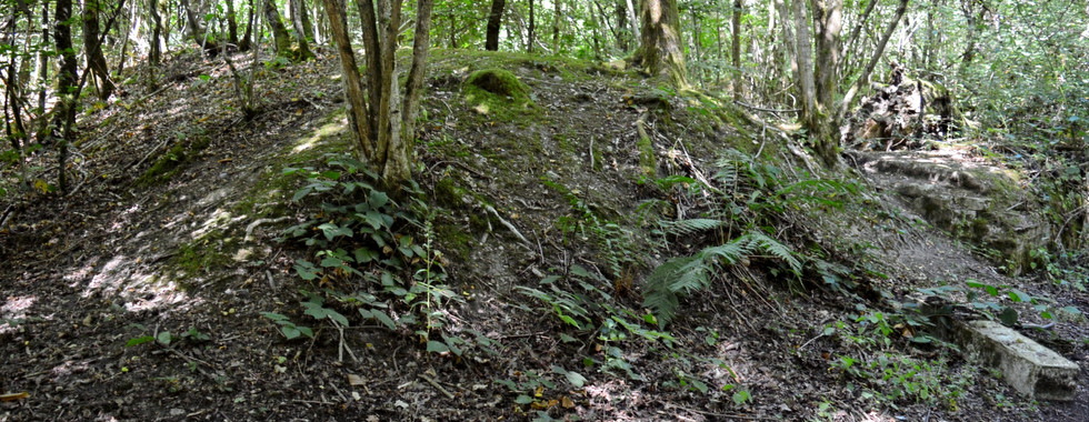
The Old Bomb Site, Bowdown Woods

A key military heritage attraction is the curiously named 'Old Bomb Site'. This site lies less than a mile east of Bowdown House in Bowdown Woods between the River Kennet and Burys Bank Road. The 40-acre nature reserve once belonged to the Ministry of Defense, which used the secluded woodland and heathland to house munitions stores. These supplied the RAF/USAF airbase at Greenham Common during the Second World War and possibly during the early years of the Cold War. According to West Berkshire's entry in Heritage Gateway (HER), the Bomb Stores are believed to have been inactive by the 1980s.
Limited physical evidence of this site exists today. The network of old surfaced tracks remains intact. Along one route of the nature trail, guests will reach a fork, (highlighted green on the map above). The densely wooded area between these parallel tracks contains the highest proportion of evidence of this wartime complex. At least eight to ten rows of rectangular earth mounds are sequentially stationed along here.
A low brick and concrete wall with metal ring fittings spans the entirety of the southernmost track and is in remarkable condition despite considerable damage and overgrowth. Possibly two more mounds are based in the northernmost part of the reserve. The flatter terrain housed other buildings long since vanished from the landscape, (highlighted orange). These structures were apparently demolished between fifteen and twenty years ago.


The final remnant of the Bomb Stores is the pistol firing range, (highlighted purple). A steep, overgrown path leads off the main track down to a bank near the river. Make sure to wear long trousers! Old concrete posts which once enclosed this area now litter the ground. Definitely something for the metal detectorists!


What3words Address: family. holly. feast
Nissen Huts, Limberlost Farm

The Nissen Huts adjacent to Limberlost Farm on Crookham Common are perhaps the most ambiguous military monument in this area. An Ordnance Survey map published in 1971 shows eight huts situated on the field south of Limberlost Farm. Another map published in 2011 lists only four. Today, only three huts remain.
Unlike the lone Nissen Hut by Highfield Farm on Crookham Common (what3words address: recruiter.repayment.stitch) which interned Italian and German POWs during the Second World War, the purpose of the Limberlost Nissen Huts is less clear.
Were they part of RAF Greenham Common or the Limberlost Bomb Stores?
Prefabricated steel structures such as these were often repurposed for storage space and emergency housing after the War. So, it is fair to assume these huts fulfilled one of these two functions.
The owners of Limberlost Farm submitted a planning application in 2020 for the conversion of these huts from their current usage as agricultural buildings into residential housing. West Berkshire Council refused the application and has dismissed subsequent appeals made over the past couple of years. Considering this ongoing legal sparring and the current dilapidated state of these huts, it is difficult to ascertain whether they will still be around in the years to come.


What3words Address: signature.spearing.contemplate
Limberlost Bomb Stores, Limberdell

The Limberlost Bomb Stores beside Limberdell on Crookham Common are comparatively better preserved than their counterpart in Bowdown Woods, located two miles west. This is because it is likely they were never used. West Berkshire's entry in Heritage Gateway (HER) cites geographic data from a series of Ordnance Surveys. A map published in 1961 does not list the Bomb Stores or RAF Greenham Common for that matter. Yet, both of these sites appear on another map published in 1970. Wartime aerial photographs and site plans also exclude the Limberlost Bomb Stores.
Did it remain unlisted in the interests of national security? Or was this because the site was never used?
Unlike the Old Bomb Site in Bowdown Woods, it is also uncertain whether the Limberlost Bomb Stores were affiliated with the nearby RAF Greenham Common during World War Two and the Cold War.
At the entrance to the fenced compound is the crumbling gatehouse. This leads to four linked parallel roads. On the easternmost track stand three huge concrete gantries. These enabled cranes to unload supplies into the structure, (see the fourth picture below). It appears as though the structure was never completed. A row of nine brick and concrete foundations and six earthworks also line the track, each with the capacity to house different military ordnance.


What3words Address: carpets.mainframe.condition
The sites highlighted above represent only a fraction of the military structures still dotted today across West Berkshire, all waiting to be properly explored!
Do you have any other information about these sites? Are there others deserving of a place on this list? Let your voice be heard in the comments below.
As for me, it is time for some more fieldwork!
Photos by Mirek Gosney
Comments